Friday, November 03, 2006

Brecon Beacons National Park

Brecon Beacons National Park (Welsh: Parc Cenedlaethol Bannau Brycheing) was established in 1957. It is situated in mid-Wales and covers an area of 520 square miles (1347 square kilometres). Its amazing landscape is now official recognized as one of the most important geological sceneries in Europe.


Tuesday, October 24, 2006


John Muir a prophet in the wilderness ( by timo )


Who was John Muir?

John Muir (1838-1914) was America's most famous and influential naturalist and conservationist. He is one of California's most important historical personalities. He has been called "The Father of our National Parks," "Wilderness Prophet," and "Citizen of the Universe." He once described himself more humorously, and perhaps most accurately, as, a "poetico-trampo-geologist-botanist and ornithologist-naturalist etc. etc. !!!!" Legendary librarian and author Lawrence Clark Powell (1906-2001), (anticipating an event that was not to occur until 2006), said of him: "If I were to choose a single Californian to occupy the
Hall of Fame, it would be this tenacious Scot who became a Californian during the final forty-six years of his life."
As a wilderness explorer, he is renowned for his exciting adventures in California's Sierra Nevada, among Alaska's glaciers, and world wide travels in search of nature's beauty. As a writer, he taught the people of his time and ours the importance of experiencing and protecting our natural heritage. His writings contributed greatly to the creation of Yosemite, Sequoia, Mount Rainier, Petrified Forest, and Grand Canyon National Parks.


His words and deeds helped inspire President Theodore Roosevelt's innovative conservation programs, including establishing the first National Monuments by Presidential Proclamation, and Yosemite National Park by congressional action. In 1892, John Muir and other supporters formed the Sierra Club "to make the mountains glad." John Muir was the Club's first president, an office he held until his death in 1914. Muir's Sierra Club has gone on to help establish a series of new National Parks and a National Wilderness Preservation System.


Theodore Roosevelt ( 1858-1919 )


last battle to save the second Yosemite, Hetch Hetchy Valley, failed. But that lost battle ultimately resulted in a widespread conviction that our national parks should be held inviolate. Many proposals to dam our national parks since that time have been stopped because of the efforts of citizens inspired by John Muir, and today there are legitimate proposals to restore Hetch Hetchy. John Muir remains today an inspiration for environmental activists everywhere.


John Muir and Theodore Roosevelt


John Muir's life reminds us of the important things that just one person can do:
"If you think about all the gains our society has made, from independence to now, it wasn't government. It was activism. People think, 'Oh, Teddy Roosevelt established Yosemite National Park, what a great president.' BS. It was John Muir who invited Roosevelt out and then convinced him to ditch his security and go camping. It was Muir, an activist, a single person." -- Patagonia founder and outdoor enthusiast Yvon Chouinard in a (
recent Sierra Magazine interview).


Bekki

Great Britain

there are 14 nationalparks in great britain:

Map Coverage : Great Britain National Parks
  • Brecon Beacons
  • Pembrokeshire Coast
  • Cairngorms
  • Dartmoor
  • Exmoor
  • Lake District
  • Loch Lomond and The Trossachs
  • New Forest
  • Norfolk Broads
  • North York Moors
  • Northumberland
  • Peak District
  • Snowdonia
  • South Downs
  • Yorkshire Dales

Brecon Beacons (Welsh: Bannau Brycheiniog)

Pen y Fan
Looking towards Pen y Fan

The Brecon Beacons is the 2nd largest park in GB, it`s situated in mid-Wales and one of Great Britains's most beautiful national parks. There are 7 million visitors per year and it covers an area of 1347 square kilometres. It was disagnated as a national park in 1957 and in October 2005 it officialy became UNESCO Global Geopark recognition for the Fforest Fawr Geopark.

The national park is well-known for it`s amazing scenery. There are the rolling hills of Black Mointan, the woodlands, the waterfalls , the highmoor but also many lakes and rivers. Brecon Beacons contains spectacular upland formations, as you can see on the left picture. Because of the different patterns of limestone and grit erosion which dominate the area,waterfalls and caves have formed over the countries. The activities you can do there are many-sided: walking, cycling, horse riding, sailing, windsurfing, canoeing, fishing, rock climbing, caving or just enjoying the amazing countrysize.


Ystradfellti Sgwd - One of the many beautiful waterfalls in the National Park


Quellen: www.breconbeacons.org
www.wikipedia.org/wiki/Brecon_Beacons

Peace!! Love!!

Monday, October 23, 2006

THE LAKE DISTRICT

IN BRITAIN


Park OverviewAt 2,292 sq km (885 SQ MILES) the largest of England's National Parks provides an exciting mix of mountain and lake scenery. Postcard-perfect in summer, in fall the brown bracken of the mountain slopes contrasts with the reds of oak forests and the beginnings of snow-white frosting on the mountain peaks. The Lake District is a walker's paradise at any time.

Be warned: the weather can change suddenly, and even if it looks fine at lower elevations, the peaks may be subject to unpleasant conditions. Always check the weather forecast before setting out


like this :


Here is al small card of "THE LAKE DISTRICT",
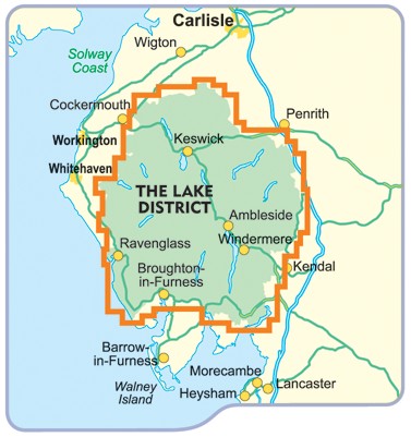
where you can see wehre it is and whats around it is.


The Lake District National Park is one of fourteen National parks in the United Kingdom. It lies entirely within Cumbria, and is one of England's few mountainous regions. All the land in England higher than three thousand feet above sea level lies within the Park. The Lakes, as the region is also called, were made famous during the early 19th century by the poetry and writings of William Wordsworth and the Lake Poets.


This post was written by maximilian andreas staehle .

I got the informations from the WWW you can see bigger sides like this in google if you want.


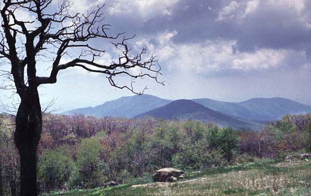
EVERYRI NATIONAL PARK (SNOWDONIA) NORTH WALESE or the Snowdonia National Park was designated a National park in 1951, the third National Park to be created in England and Wales under the 1949 National Parks and Access to the countryside Act. It is the second largest National park in England and Wales, covering some 26,171 square kilometres (8538 square miles) of north west Wales, and including the Carneddau, and Glyderau mountain ranges as well as the Highest mountain in England and Wales (1385m/3960ft)- Yr Wyddfa (the Tomb in welsh), or Snowdon from which the Park takes its (english) name. The welsh name Eryri means 'place of the eagles'.
Crib Goch and the summit of Yr Wyddfa in winter

Kathrin Schweinberger
Snowdonia National
Park


Facts of Sno
wdonia:
In Wales there is the second largest national park in Great Britain called Snowdonia (Welsh: Parc Cenedlaethol Eryri; eryri means "place of the eagles"). It was established in 1951 as the first national park in Wales and it covers 838 square miles (2171 square kilometres) of beautiful scenery. The national park has 23 miles (37 kilometres) of coastline with many sand dunes.
Snowdonia isn't such a wilderness area as many other national parks, but it's a landscape where 27500 people live and work.

The Park Profile from 2004:
Welsh speakers: 55%
unemployed people: 6%
woods: 36ha
day visitors: 51%
stay visitors: 49%

Mountains:
There are a lot of mountains in Snowdonia. The youngest of them is called Silurian and is over 400 million years old.
The five biggest mountains in Snowdonia are Yr Wyddfa(1085m), Crib-y-Ddysgl(1065m), Carnedd Llywelyn(1064m), Carnedd Dafydd(1064m) and Y Glyder Fawr(999m).

Here are some more:
Tryfan; Cader Idris


Lakes:

There are over a hundred lakes in Snowdonia which have more than an acre in size. They are all over the national park from the north to the south and from the east to the west. The lake far in the north is called Llyn Gwern Engan, in the south Llyn Barfog, in the east Llyn Tegid and in the west Llyn Cwmdulyn.

Here are some more:
Nant Gwynant; Cwm Idwal; Llyn Tegid


Woodlands:

In Snowdonia there are 30.000ha of woods; 1.000ha mixed woodlands, 25.000ha coniferous woodlands and 10.000ha broad leaved woodlands. They cover about 17% of the whole national park.

Here are some photos from different woods:


Rules:
- stay on paths
- take your litter home
- don't make noise
- have a permission for camping
- keep your dog under close control
- don't feed cattle
- close gates

Information Centres:
There are a lot of information centres in Snowdonia. They are all over the national park. There you can ask for information on local events, attractions, activities or the public transport. From there you can also book accommodation locally or guiding tours or you can buy some souvenirs.

The centres look like this:


Wild life:

In Snowdonia there live so many different animals, that you are fascinated by them. You can watch buzzards, otters, snakes and a lot of colourful birds which give you the feeling that you are really in the nature. It's fantastic.

Attractions and activities:
Snowdonia has many attractions on offer, for example Penrhyn Castle where you can visit exhibitions, museums and some shops with souvenirs or the Centre for Alternative Technology which is Europe's leading eco-centre. You can also try to find your way out of King Arthur's Labyrinth.
There are a lot of activities, too, for example surfing, canoeing, kayaking, coasteering, climbing or abseiling. You can also be taught in these activities.


Quelle
www.eryri-npa.com

Wrangell-St. Elias National Park in ALASKA ( by timo )

Wrangell-St. Elias National Park & PreserveThe Chugach, Wrangell, and Saint Elias ranges converge here in what is often referred to as the "mountain kingdom of North America." The largest unit of the National Park System, this spectacular wilderness includes the continent's largest assemblage of glaciers, and greatest collection of peaks above 16,000 feet, including 18,008’ Mount St. Elias, the second highest peak in the United States.


Did You Know?
Ten million swans, geese, and ducks nest in Alaska each year. That's ten times the population of people in Montana!
Only female mosquitoes bite. They use blood for egg production.
Iceworms really do exist! A small segmented black worm, less than an inch long, the iceworm lives in temperatures just below freezing. They can be found in the ice on the surface of glaciers (look like black threads).
In Alaska, caribou outnumber people. There are about 616,000 people in Alaska and 900,000 caribou.
Alaska has NO reptiles and NO rabbits (they are all hares). A rabbit is born without hair; hares area born with hair already. In Alaska, you need all the warmth you can get!

Elusive WildlifePeople often ask, "Where is the wildlife in Wrangell-St. Elias?" The answer is - wildlife is everywhere - you just need to know where to look for signs of it!
Be A Nature DetectiveAlthough you may not see a bear or lynx, if you look closely, you might see signs that they've been in the neighborhood! Animal tracks and scat, animal droppings, might be as close as looking down at your feet. A red fox leaves a strong scent where it has been. Check tree trunks for bear scratches or hair.
Where ARE the animals?In spring, melting snow allows plants to start sprouting in the high mountains. Many animals leave the spruce forests and travel higher to find these sweet and nutritious young plants. Heading higher also takes them away from fli


Dartmoor Naitional Park

Dartmoor became a National Park in 1951. It is a Nanational Park near Plymouth.
It has a size of 954km² and is famous for the Clapper-Bridges.There you can find also over 2000 years old meetingpionts.

People like Sir Athur Conan Doyle wrote their scarry stories like "The Hound of the Baskervilles" because of the inspiration of this National Park.The People also tell storys about prisiners,who escaped from the Dartmoor prison and died in the moor. But the National Park is like many National Parks.That means that some ifactory-owners want to build there factories and destroy so the National Park .

This is a Clapper-Bridge:

It is over 2000 years old and was bulid by the people who lived in Britain over 2000 years ago

Here Dartmoor National Park starts:

This is an old castle in Dartmoor National Park :

In the north of Dartmoor National Park the british armee practice to shoot,but the Dartmoor Preservation Association and the Open Space Society try to protect Dartmoor National Park from this using of it.

This is the Beardownman.It is a ca. 3metres high Stone that is isolated from the other stones. It is one of the mystery things of Dartmoor.

Qellen: http://www.dartmoor-npa.gov.uk/ and http://de.wikipedia.org/wiki/Dartmoor By Alexander Schreider


Shenandoah National Park, Virginia, United States


(Quelle Bilder : www.parksonline.org )

.

Shenandoah National Park is located in northwestern Virginia, northwest of Charlottesville, Virginia. The Park is about 75 miles west of Washington, DC.

(Origin pictures: www.us-national-parks.net )

.

Black Bears
Black Bears are the only type of bear found in Shenandoah National Park. Although they are carnivores, their diet is quite varied. They'll eat grubs and other insects, roots, flowers, grasses, acorns, fruit, and carrion, as well as ground hogs, deer, and other mammals. Bears in the park enter winter dens in October and November, but some may rove about all winter if the temperature is mild. Females will have their cubs around February, and nurse their infants in the den. They'll emerge in April or May, usually after the adult males have been out of their own dens for a while. Mating time is early to mid summer. A female will keep her newborn cubs with her until she is ready to mate again, every other year. The park believes there are from 300 to 500 bears in Shenandoah National Park.

Peoples Before the Park
For at least 10,000 years people have lived on the Blue Ridge Mountains. Prehistoric humans have hunted and gathered game, fruit, nuts, and berries on the upland slopes, and some may have constructed permanent villages at the lowest elevations near the Piedmont and Shenandoah Valley.
The earliest European settlers moved into the lower areas of the mountain range by the mid-18th century, ever moving upward in search of land for farming, grazing, and orchards. Later, some owners purchased mountain land for the extraction of resources: copper, lumber, bark for tanning of leather, and water power for the operation of mills. Others early saw the beauty of the Blue Ridge as a commercial product in itself, and built resorts catering to visitors from the cities. (Origin text: http://www.shenandoah.national-park.com/ ) (Origin picture: www.cr.nps.gov )

Shenandoah was authorized in 1926 and fully established on December 26, 1935.

Babette Oller

Mona Reinhardt- The New Forest

History of the New Forest

Homy RidgeThe New Forest was named Nova Foresta following the Norman Conquest of 1066. The Forest originally covered a larger area than today, stretching from Salisbury to Bournemouth and Southampton Water to the east. The Forest is divided between woodland, open heathland and land set aside for agricultural purposes.
The forest was privatly used by William the Conqueror in 1079 for hauting wild animals. With this, William removed the law which said that nobody was allowed to kill animals and a strict Forest Law was introduced. Forest Law, among other things, inflicted severe punishments for anyone found interfering with the deer in the Forest, with the penalty of death for killing one.
The peasants were given the right to allow their livestock to roam free on the Forest as a trade off for being prohibted from erecting fences. Fences would have disturbed the King by his hunting party.
With domestic animals allowed to roam free of wild deer in the Forest, saplings were damaged and because of such an extent the new growth of vegetation was hindered. The growing demand for wood, the first Inclosure Act was passed in 1482. To create new woodlands the people closed large parts of the Forest and the Forest had changed from the hunting ground of the eleventh century to an important source of timber. As hunting became less important the large numbers of Deer were deemed unnecessary. because they caused damage to the vegetation. In 1851, the Deer Removal Act was introduced to get the deer out of the Forest.


Conifers push out the oak
Up until the late eighteenth century the Oak was dominant in the Forest. This was to change with the introduction of faster growing softwood conifers.
In the eigthteenth and nineteenth centuries the strengh and quality led the New Forest Oak to be used in the construction of naval ships at Buckler´s Hard.


The Verderers
The Court of the Verderers was created around the twelth century to provide officials to deal with offences in the forest. It still sits in the Verderers' Hall, Queen's house, Lyndhurst. The name Verderers comes from the Norman 'vert' which means green. Today it consists of one official, five elected and four appointed verderers.

Quelle:
http://www.thenewforest.com/history_of_the_forest.php

by Mona Reinhardt

Aleksej


Canonlands-Naionalpark
size : 1.3566 km²
established 12. September 1964
Utah 3708.001 visitors (20030)

Canonlands Naional Park Utah
In the far southern reaches of Utah, the Colorado and Green Rivers carve the high desert into a labyrinth of red-rock canyons that are sheer ecstasy for the hiker, mountain biker, and whitewater adventurer. The park is broken into three distinct districts — Island in the Sky , The Needles and The Maze . The vast landscape offers hundred-mile vistas of rust-colored pinnacles, high mesas, sculpted buttes, sandstone spires, and sheer crimson cliffs.


Klima

The Klima in Canonlands is extremely dry. Most precipitation falls in early spring and late summer. Summer highs often exceed 100 Degrees Fahrenheit, with lows in the 60's. Fall and Spring temperatures are milder, with highs in the 70's and 80's. Winter temperatures range from highs in the 40's and 50's to lows well below freezing. Snow is usually light to moderate.


Nature & Science

Canonlands preserves one of the last, relatively undisturbed areas of the Colorado Plateau, a geologic province that encompasses much of the Colörado Rüver and its tributaries. Carved out of vast sedimentary rock deposits, this area possesses remarkable natural features that support a fascinating desert ecosystem.

Tuesday, October 17, 2006

Abraham Lincoln Birthplace National Historic Site
The Site focuses on Lincoln’s life in Kentucky. The Birthplace Unit demonstrates his humble beginnings with a symbolic birth cabin enshrined within a neo-classic Memorial Building. The Boyhood Home Unit at Knob Creek Farm was home to Lincoln during his formative years. Events in Kentucky helped mold a young boy into the man who became the nation’s sixteenth President.

Abraham Lincoln Birthplace UnitThe Birthplace Unit features 116 acres of Thomas Lincoln's Sinking Spring Farm. An early 19th century Kentucky cabin, symbolizes the one in which Abraham was born. The cabin is enshrined inside the Memorial Building at the site of his birth. The Unit also includes the Sinking Spring, site of the Boundary Oak tree and other reminders of the Nation's 16th President's beginnings.

Boyhood Home Unit at Knob Creek“My earliest recollection is of the Knob Creek place.” So wrote Abraham Lincoln on June 4, 1860. The Lincoln family lived on 30 rented acres of the Knob Creek Farm from the time Abraham was two until he seven years old. As President, he said he could remember planting pumpkin seeds in the garden in every other hill and in every other row while others were planting corn. The following day a big rain in the hills flooded the creek and washed away their garden.

Abraham Lincoln Bicentennial
You're invited to participate in the 200th birthday commemoration of the 16th President of the United States, Abraham Lincoln. The Abraham Lincoln Bicentennial opening ceremony will be held at Abraham Lincoln Birthplace National Historic Site in Hodgenville, Kentucky on February 12, 2008.
For additional information phone (270) 358-3137

produced by: C.Kumar (from:http://www.usatourist.com/photos/california/yosemite4a.jpg)
Yosemite Nationalpark is located in the central Sierra Nevada of California and lies 150 miles east of San Francisco and only a six-hour drive from Los Angeles.Yosemite is internationally recognized for its spectacular granite cliffs,waterfalls,clear streams and giant sequoia trees.


Here you can see Yosemite Falls.It´s 2425 feet (800 meters) high and it is one of the most fascinating attractions in Yosemite Nationalpark.There are nine further waterfalls and five of them are about 1000 feet (300 meters) high.But the nationalpark includes many other natural attractions,too.Such as the Grizzly Giants,which are 300 feet tall and have trunks up to 30 feet (10 meters)

(from:
http://mypage.bluewin.ch/edlibaer/amerika/aug30.jpg)

The GAYLAND Park


Michael Staudenmayer (GAY)

Brighton is surrounded by the chalk downlands and countryside of Sussex. Much of the district is designated an Area of Outstanding Natural Beauty and is characterised by gently rolling hills, hidden valleys and dense woodland and the chalk escarpments of the South Downs - soon to become a National Park. The beautiful Cuckmere Valley and Seven Sisters Country Park runs from Lewes to the sea and is set against the spectacular white cliff coastline.Visit a wide range of attractions such as magnificent gardens of Merriments, Groombridge place, Leonardslee and Borde Hill. Visit fairy tale castles and historic houses, including Bodium Castle, Uppark, Elizabethan Hertsmonceaux Castle, and the Bloomsbury Group’s country retreat, Charleston Farmhouse.Sample Fine wine at The English Wine Centre near the picturesque village of Alfriston or relive the most famous date in English history at the Ruins of Battle Abbey, situated in 1066 Country near Hastings.
(www.heritagecities.com/brighton/countryside.asp


Welcome To Seven Sisters Country Park
This site provides information on Seven Sisters Country Park, which is situated in the Sussex Downs Area of Outstanding Natural Beauty in southeast England.
It is a popular location for a number of outdoor activities including walking, cycling and canoeing.
The Country Park is named after the famous Seven Sisters that form part of the Sussex chalk cliffs on Britain's heritage coastline.
For information on how to get to the Country Park please go to How to get here.
See What to do for information about recreational opportunities and facilities in the Country Park.
If you are a teacher or a student and require information on educational opportunities at the Country Park please click on Education.
Click here to view the site map.
The Park is managed by the South Downs Joint Committee.
For information about the South Downs and the proposed National Park visit the South Downs Virtual Information Centre

Seven Sisters Country Park
Found either side of the River Cuckmere in a designated Area of Outstanding Natural Beauty and covering some 700 acres (280 hectares), Seven Sisters Country Park features open water, salt marsh, meadow, areas of bare chalk, shingle, chalk cliffs, picnic area and a number of eighteenth-century flint barns (one contains The Living World exhibition and one the information centre).

Seven Sisters Cliffs
The Seven Sisters cliffs have been witness to the demise of many ships and seafarers, the local inhabitants being quickly on the scene to rescue crew and salvage any valuables. And since 1563, there have been at least 25 shipping casualties between Birling Gap and Cuckmere Haven.
The first occupiers of the area were prehistoric people; many items of evidence to their presence here have been recovered in the form of tools fashioned from the hard flint found within the chalk - these include axes, some polished or smoothed. The coast of Sussex was notorious for smuggling exploits and the remote shingle beach situated at Cuckmere Haven is where scrapers and arrowheads have been found.
The white rock was formed under the sea millions of years ago from minute marine algae and fragments of seashells. The cliffs are receding at about 30-40cm each year on average. The process is intermittent with major falls occurring after heavy rain or rough seas, often two of three times per year. Where these falls occur they protect the base of the cliffs from the sea, and usually there are no falls in the same places for eight or nine years until the sea undercuts the cliffs again.
The Visitor Centre is situated in an 18th century barn and provides useful information on the cliffs and the country park with displays and exhibitions.
The area has a long and interesting history, including some fascinating shipwrecks, which you can discover on a series of shorewalks, and you can use your bike to explore the other areas of the park if you have time.
Seven Sisters Country ParkExceatSeaford


Exmoor National Park (http://www.britainexpress.com/countryside/Exmoor.htm


Basically a huge sandstone plateau split by deep coombes, or wooded valleys, Exmoor is home to some of the most varied and beautiful scenery in England. The moors contain large deposits of peat, which form bogs due to the high rainfall. Mist and fog can descend very quickly in Exmoor, so a compass is a must for walkers. The peat moors give way to heather uplands, replete with a variety of grasses and plants, such as gorse and whortleberry.
Wild Exmoor ponies still graze here side by side with red deer, the largest of England's native animals.The lush green coombes, dominated by oak woods, are home to a variety of bird life, such as grey wagtails, kestrels, buzzards and ring ouzels.
The National Trust owns large portions of Exmoor, notably the Holnicote estate, containing Dunkerry Beacon, the highest point in Exmoor. There are over 100 miles of walking paths within the vast (12, 500 acres) estate. The Trust publishes a leaflet detailing 14 walks around Dunkerry. Pretty villages dot the Park, such as Dunster and Selworthy, a favourite of postcard and calendar photographers.

Selworthy
Exmoor is also home to Lorna Doone, fictional heroine of Victorian author R.D.Blackmore. Blackmore's descriptions of the scenery are so precise that even today it is easy to recognise many of the sites described in his book. The village of Malmstead is a good jumping-off place for visiting "Doone country", and Oare contains the church where Blackmore had Lorna and hero John Ridd marry.

Everglades National Park, Florida, United States


(Origin pictures: http://www.phy.duke.edu )

There is only one Everglades in the World.
Everglades National Park is the largest subtropical wilderness in the United States. The area boasts rare and endangered species, such as the American crocodile, Florida panther, and West Indian manatee. It has been designated an International Biosphere Reserve, a World Heritage Site, and a Wetland of International Importance, in recognition of its significance to all the people of the world.


Hurricane Update

In 2005, many facilities in Everglades National Park were damaged by hurricanes Katrina and Wilma. The Flamingo area and associated facilities suffered extensive damage. While recovery efforts continue, most of the facilities in the park are open and accessible.

(Origin picture: http://www.cclockwood.com )

(Origin text: http://www.nps.gov )

The area was authorized as a national park on May 30, 1934, but it was not fully established until December 6, 1947. The park was designated an International Biosphere Reserve on October 26, 1976. On November 10, 1978, most of the park was declared a wilderness area. Wilderness designations covered 1,296,505 acres (5247 km²) in 2003 — about 86 % of the park.

Everglades National Park is surrounded by the urban and agricultural areas of Miami, Homestead, and Florida City to its east, the Florida Straits and Florida Keys to its south, the Gulf of Mexico to its west and Big Cypress National Preserve to its north. Big Cypress is similar to the northern portion of the Everglades and it is about half the size of the park itself.

(Origin text: www.wikipedia.org )

(Origin picture: http://www.interweave-consulting.com/ )

You can also look at http://www.everglades.national-park.com/ , there you´ll find a lot of information about Everglades National Park.

Babette Oller